What goes on behind the cockpit door...
Hang on for John Cleese' punch line...totally worth it:).
posted by Delta Whiskey @ 10:41 PM
0 comments
![]()
About 80% of general aviation aircraft fly using Lycoming engines. Clearing the trees at the end of the runway. Leaving 4500ft for 6500ft. Maintaining airflow and generating lift across the wings. All are impossible without a reliable engine. Lycoming powers my training aircraft and so fuels my quest for a private pilot certificate. This blog is a record of my thoughts and experiences on life, flight, and learning.
posted by Delta Whiskey @ 10:41 PM
0 comments
![]()
 Well, once I saw that mall, I descended, entered the pattern and took a nice smooth landing on Runway 28. I was only 1 minute behind my scheduled landing (most likely due to forgetting to account properly for climbout). I back-taxied and promptly took off for Canton-Akron (CAK). As soon as I passed 2,000ft, I called Youngstown approach for clearance through the Youngstown Class C. We flew over the tallest radio tower for miles around - 2500ft MSL at 4500ft, and it didn't feel like we flew over it by very much. Once we were out of Youngstown airspace, they put us back on VFR, and we were headed to CAK.
 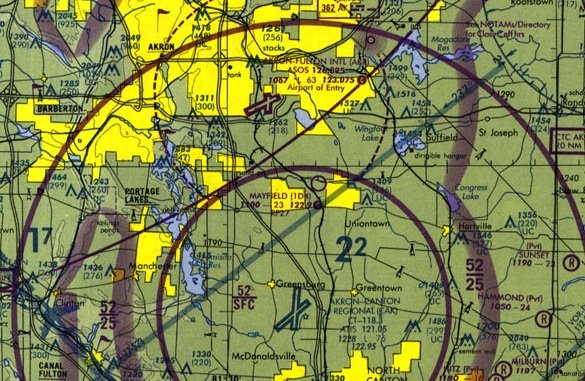 We had been listening to CAK approach for about 5-10 minutes prior to our initial radio contact, and there wasn't much happening. So we waited until we were about 20nm out before contacting CAK approach. I must admit that I was a little sheepish as I intoned "Canton-Akron Approach, Cessna November-7-1-0-6-Golf" a couple of times with no acknowledgment from the controller. There had popped up a bunch of arrivals, some that were visual and some that were ILS, and he just didn't have time to talk to me. Finally after about 4-5 tries to communicate, the last of which was a little on the forceful side (from Walt), we received a frequency code and admission to Class C airspace. There was a decent amount of traffic out and about (saw the Goodyear Blimp at about 3000ft), but we were cleared to land from about 5 miles out.
 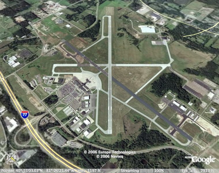 Because of our western heading, I entered the pattern on the base leg, and practically had a straight-in approach from about 3 miles out. It's a nice, long, wide runway, but I managed to land nicely, and not flare 10 feet above the pavement as I had in Mansfield. We requested a full-stop landing, so I turned on the first taxiway and held short as a AirTran 717 landed on Runway 19 right in front of me!
  There were a couple of Canadair RJ's and even a 747-200 parked on the ramp. It was pretty exciting for me! I felt like I was a big shot, landing at an airport with the big boys (even though my C172 would've been blown over by all of them). I saw in my mind's eye, a little kid looking out the window of the airliner as it rolled to a stop saying "Look, mommy! Look at that little plane with the propeller!". Yeah, time to head for home:). I taxied back to Runway 23, and took off for home. We crusied at 2500ft, and Walt pointed out just about every Amish restaurant between Canton and Coshocton on the way back. About 35 miles from I40, we again spotted the smokestacks of Conesville, and knew that we were headed in the right direction.
posted by Delta Whiskey @ 10:28 PM
0 comments
![]()
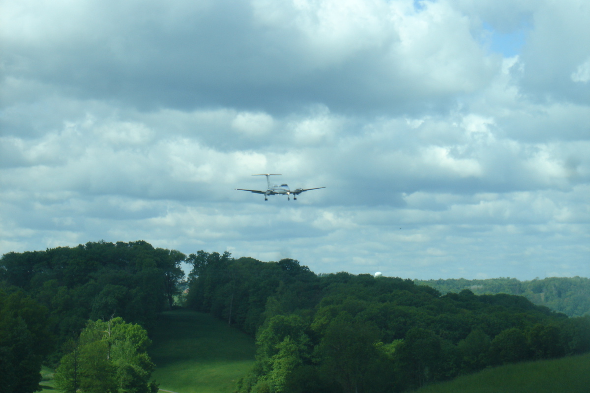
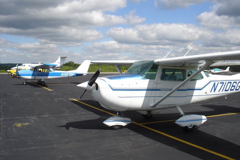 Saturday was the first day without rain in 9-10 days...We had a huge low-pressure zone camp out over Chicago and the midwest for a while, and finally it cleared off enough to exercise the ol' Cessna 172. As you can see from the photo, there were several other pilots out enjoying the break in the weather. It was my first real practice with some 90degree cross-winds, so landings were a little on the challenging side. I practiced some nice long approaches, setting up a forward slip and getting those landings done right. It was definitely harder, and I do need some serious practice. No landings were a big problem, but I was having trouble flaring at the right time and getting the airplane on the runway at the spot that I was aiming for.
 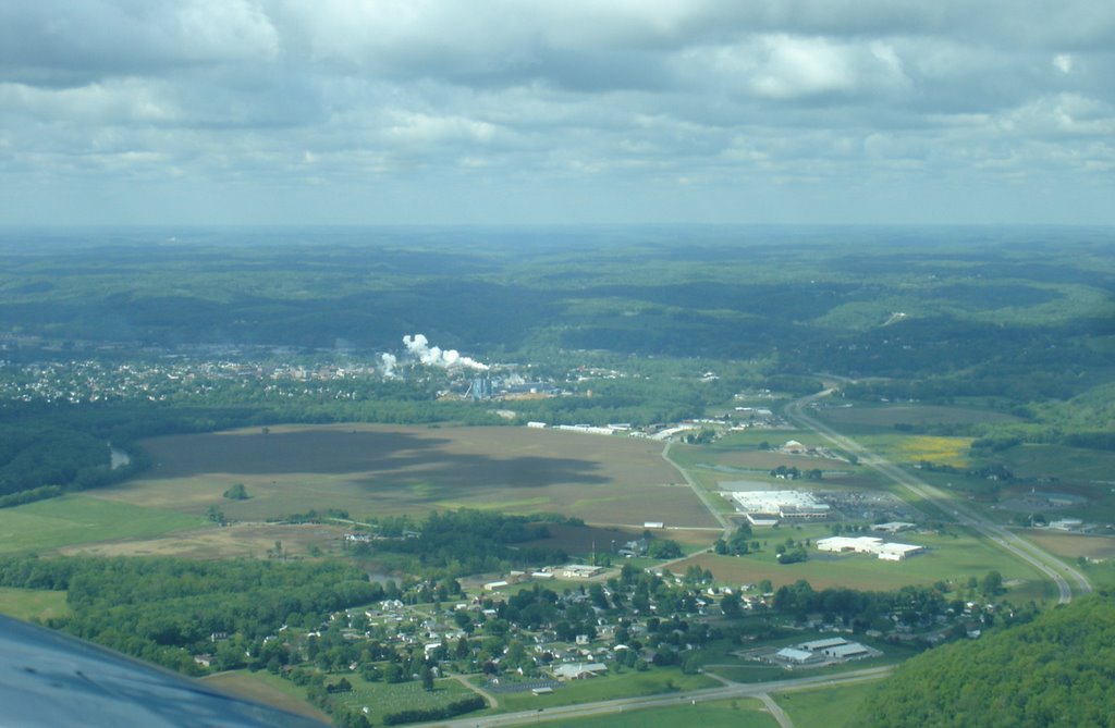 Coshocton is really green right now! It's just astounding to look at this place from the air and see how much it has changed since March (see photo below).
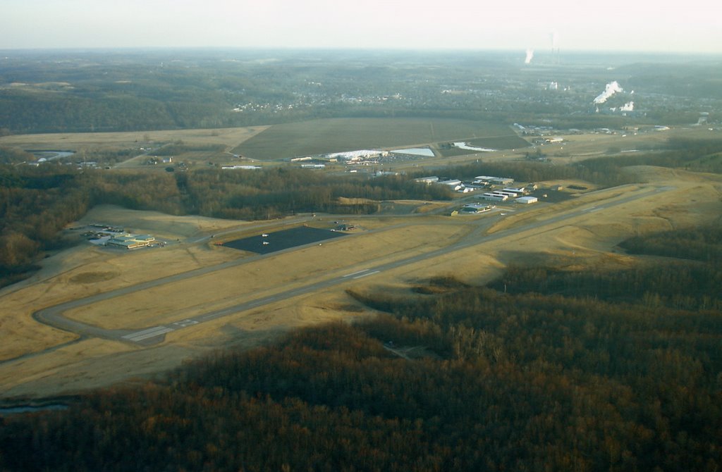
posted by Delta Whiskey @ 9:56 PM
0 comments
![]()
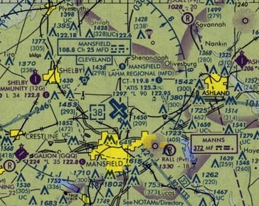 Today, I flew to Mansfield Lahm Airport (MFD) for my second cross-country flight with my instructor. According to the GPS, MFD is 49.6nm from I40, so it didn't qualify as a 50nm cross-country, but it was still a good learning experience for me in the airplane. Using the ol' E6-B slide-rule flight computer, I plotted my course, which I followed by dead reckoning and pilotage. It would've been easy to use the VOR's (Mansfield has one and Coshocton is right next to the Tiverton VOR), and the "direct to-" function in the Garmin 430 GPS is very easy and has a lot of functionality, but I wanted to see what it was like to figure out the winds, magnetic deviation, and plan my course to MFD. Based upon the winds of 7kts @ 160°, I chose a course heading of 320° for the flight up. The winds were calm at I40 at my departure at 12:15Z, with some light clouds at 4000ft, but the sky was clear towards MFD with some ground haze below about 4000ft. Visibility at 4500ft was only about 15nm, with the sun behind us. I picked out my landmarks with ease, and recorded my anticipated times (only 30 seconds off!) and after about 20 minutes, I could just make out runway 32, lined up perfectly with my desired course. It was a satisfying feeling to do the math, figure this course out, and set it without being able to see the destination, and end up at the right spot! MFD was my first towered airport, so I called approach, got a transponder code, was passed off to the tower, and I flew my first right-hand pattern! MFD has a very wide runway (9000ft x 150ft wide) and so it felt like I was landing on a huge parking lot, and so I flared about 5-10ft too high. I realized my error, and adjusted for a beautiful greaser of a landing on the runway. We quickly turned around and departed back to Coshocton, and once the plumes of Conesville and Smurfit-Stone were in sight, I knew I was home. Next week, I will plan a 2-hour cross-country for a couple of routes.....I hope the weather is good!
posted by Delta Whiskey @ 10:15 PM
0 comments
![]()
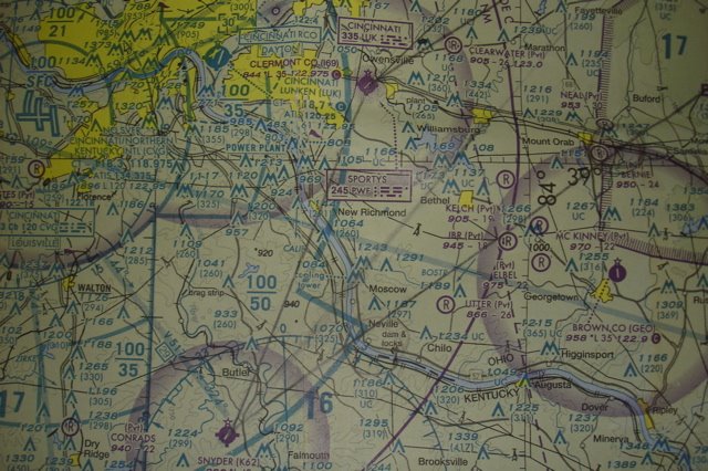 Last thursday (April 27th), I flew down to Gene Snyder (K62) with the senior member of my flying club, Ed. He was visiting some family in the Butler, KY and needed a co-pilot for the flight. Hey, X-country practice time for free? You betcha! This was a welcome opportunity, because my XC to MFD was canceled on Tuesday due to bad weather. I reviewed all the course planning information with my instructor and then laid out two courses to K62, approximately 160nm away. I had to plan one course through the Brush Creek and Buckeye MOA, and an alternate around the MOA to the northwest. We would find out if the MOA was "hot" from Columbus approach in the air. Thursday morning came, and the weather was fabulous! Winds calm @ 1400Z pretty much across the state of Ohio. The prevailing winds at 5000 and 6000ft were forecasted to be heading west, which would be perfect for the flight back.
 After leaving I40 and climbing to 6500ft, we flew over one of my favorite places in my part of the world. Dawes Arboretum, a 1150 acre preserve of hundreds of rare and indigenous trees and plants, about 5 miles south of Newark, Ohio, is an absolutely wonderful place to spend an afternoon. The photo here shows part of the 2000ft hedge that spells out "DAWES ARBORETUM" in huge letters, convenienty visible from the air:). Continuing on our flight, we flew down to Circleville (CYO) where CMH approach informed us that the MOA was active, and that we should plan to fly around. I dialed in Fayette County (I23) into the Garmin 430, and we headed due west towards Washington Courthouse and Wilmington Airpark. During our flight by Wilmington (KILN), we viewed a DHL 727 taking off, and another DHL 727 and 767 on final approach and landing. For a small town boy like myself, it's really exciting to see some heavy(ier) metal than the Cessnas and Pipers that I am used to spotting in the skies. We headed closer to CVG airspace and overflew Clermont County (I69), home of Sporty's, where we saw quite a lot of GA traffic on this clear and sunny day. A few minutes later, we crossed the Ohio River, just over the dam and locks near Neville.
  Once on the ground at Snyder, we toured the various hangars and met with a Comair pilot who was testing the new smoke system in his Christen Eagle. Ed's nephew showed us around his 1967 Piper Aztec, which was termed "the mother ship" when he siphoned gas on occasion to transient pilots before they got their 24-hr credit-card operated pump. He also sits on the airport board, and it was fun to hear about his plans for the future expansion of the airport. Good luck, Dan! Hopefully, I'll be back soon to get a ride in one of those Christen Eagles!
posted by Delta Whiskey @ 8:47 PM
1 comments
![]()
A little kid trapped in a grown-up body that pretends to be an mechanical engineer during working hours, but mostly likes to look up into the sky and make airplane noises.
