Endorsed!
I finally got my cross-country endorsement! After having my flight scrubbed on Tuesday, I didn't think that I would be able to get up in the air and enjoy some of this great weather we were having before another front came through. Well, I was able to fly my long cross-country with my instructor today. We logged 2hrs 20minutes of flight time and my flight planning estimates were pretty accurate, so I was pleased with that.
Since this was my flight to plan, I picked out two routes, depending upon the weather. The westerly route was to fly to Don Scott Airport (KOSU) in Columbus, then on to Neil Armstrong Airport near Wapokeneta, OH, and back to Coshocton. The easterly route took me direct to Grove City, PA, then back to Coshocton via Canton-Akron. Both routes gave me the opportunity to land at an airport inside Class C airspace, and a landing at a class G airport over terrian that I was not familiar with. Well, I was familiar with the destinations, just not the journey:).
Western Route - If you recall from my previous posts, Don Scott was an airport that I used to sit on a pile of mulch and watch C-152's take off and land all day, so I wanted to fly in there and see what it was like to be one of those student pilots, up in the pattern, talking to the shadowy figures in the control tower. Wapokeneta was a nice distance from Don Scott and was over unfamiliar terrain, but with the lake of St. Mary directly behind it, so that I would have a hard time losing the airport.
Eastern Route - Grove City was the location of my Alma Mater, Grove City College. I hadn't visited GCC for some time, perhaps 4-5 years. When I was a student, I recall one of my roommates having a prospective student and his family come to tour the campus. They flew in their private plane, which I thought was really cool, and my roommate talked about how cool it was to see the campus and the terrain around Grove City from the air. I wanted to be up there, in the air looking down, but I didn't know what or how to begin. Also, oftentimes there were people that plunked $100 down for a chance to jump out of a perfectly good airplane, something that I was forbidden to do (as long as I was on my parent's insurance). I didn't want to jump so much as I just wanted to see what it looked like from 10,000ft.
Well, since there was a front approaching from the West, I decided to pursue the eastern option. Walt & I took off from I40 at about 3:10PM (1710Z), and headed for Grove City. I learned about picking landmarks. Sometimes towns are a good option, but sometimes not. It can be hard to differentiate one town from the next, but I managed to stay focused and kept track of the towns. When we got within about 7 miles of Grove City (29D), I couldn't see the airport. I kept looking for a runway, and a huge outlet mall with parking lot right next door. I kept looking and looking for this huge mall, and before I knew it, I was looking at the outlet mall about 4-5 miles away. I wish I had a photo of it, because it was about 1/5 of the size I was visualizing it to be in my mind. Maybe you can see the airport on this image from Google Earth. Well, once I saw that mall, I descended, entered the pattern and took a nice smooth landing on Runway 28. I was only 1 minute behind my scheduled landing (most likely due to forgetting to account properly for climbout). I back-taxied and promptly took off for Canton-Akron (CAK). As soon as I passed 2,000ft, I called Youngstown approach for clearance through the Youngstown Class C. We flew over the tallest radio tower for miles around - 2500ft MSL at 4500ft, and it didn't feel like we flew over it by very much. Once we were out of Youngstown airspace, they put us back on VFR, and we were headed to CAK.
 We had been listening to CAK approach for about 5-10 minutes prior to our initial radio contact, and there wasn't much happening. So we waited until we were about 20nm out before contacting CAK approach. I must admit that I was a little sheepish as I intoned "Canton-Akron Approach, Cessna November-7-1-0-6-Golf" a couple of times with no acknowledgment from the controller. There had popped up a bunch of arrivals, some that were visual and some that were ILS, and he just didn't have time to talk to me. Finally after about 4-5 tries to communicate, the last of which was a little on the forceful side (from Walt), we received a frequency code and admission to Class C airspace. There was a decent amount of traffic out and about (saw the Goodyear Blimp at about 3000ft), but we were cleared to land from about 5 miles out.
  Because of our western heading, I entered the pattern on the base leg, and practically had a straight-in approach from about 3 miles out. It's a nice, long, wide runway, but I managed to land nicely, and not flare 10 feet above the pavement as I had in Mansfield. We requested a full-stop landing, so I turned on the first taxiway and held short as a AirTran 717 landed on Runway 19 right in front of me!
  There were a couple of Canadair RJ's and even a 747-200 parked on the ramp. It was pretty exciting for me! I felt like I was a big shot, landing at an airport with the big boys (even though my C172 would've been blown over by all of them). I saw in my mind's eye, a little kid looking out the window of the airliner as it rolled to a stop saying "Look, mommy! Look at that little plane with the propeller!". Yeah, time to head for home:). I taxied back to Runway 23, and took off for home. We crusied at 2500ft, and Walt pointed out just about every Amish restaurant between Canton and Coshocton on the way back. About 35 miles from I40, we again spotted the smokestacks of Conesville, and knew that we were headed in the right direction.
Landing in Coshocton, we picked up 20.6gal of fuel, which wasn't too bad for 2.3hrs of flight time. About 9gal per hour - I will put that into the memory banks and remember that fuel burn rate. Walt signed me off for unlimited cross-country to a few local airports, so I can go out on a nice day and actually land at a different airport! I'll be praticing some navigation and will put together an out-and-back cross-country, but that's for another day. Today, I got my cross-country endorsement! Woo-hoo!
Since this was my flight to plan, I picked out two routes, depending upon the weather. The westerly route was to fly to Don Scott Airport (KOSU) in Columbus, then on to Neil Armstrong Airport near Wapokeneta, OH, and back to Coshocton. The easterly route took me direct to Grove City, PA, then back to Coshocton via Canton-Akron. Both routes gave me the opportunity to land at an airport inside Class C airspace, and a landing at a class G airport over terrian that I was not familiar with. Well, I was familiar with the destinations, just not the journey:).
Western Route - If you recall from my previous posts, Don Scott was an airport that I used to sit on a pile of mulch and watch C-152's take off and land all day, so I wanted to fly in there and see what it was like to be one of those student pilots, up in the pattern, talking to the shadowy figures in the control tower. Wapokeneta was a nice distance from Don Scott and was over unfamiliar terrain, but with the lake of St. Mary directly behind it, so that I would have a hard time losing the airport.
Eastern Route - Grove City was the location of my Alma Mater, Grove City College. I hadn't visited GCC for some time, perhaps 4-5 years. When I was a student, I recall one of my roommates having a prospective student and his family come to tour the campus. They flew in their private plane, which I thought was really cool, and my roommate talked about how cool it was to see the campus and the terrain around Grove City from the air. I wanted to be up there, in the air looking down, but I didn't know what or how to begin. Also, oftentimes there were people that plunked $100 down for a chance to jump out of a perfectly good airplane, something that I was forbidden to do (as long as I was on my parent's insurance). I didn't want to jump so much as I just wanted to see what it looked like from 10,000ft.
Well, since there was a front approaching from the West, I decided to pursue the eastern option. Walt & I took off from I40 at about 3:10PM (1710Z), and headed for Grove City. I learned about picking landmarks. Sometimes towns are a good option, but sometimes not. It can be hard to differentiate one town from the next, but I managed to stay focused and kept track of the towns. When we got within about 7 miles of Grove City (29D), I couldn't see the airport. I kept looking for a runway, and a huge outlet mall with parking lot right next door. I kept looking and looking for this huge mall, and before I knew it, I was looking at the outlet mall about 4-5 miles away. I wish I had a photo of it, because it was about 1/5 of the size I was visualizing it to be in my mind. Maybe you can see the airport on this image from Google Earth.
 Well, once I saw that mall, I descended, entered the pattern and took a nice smooth landing on Runway 28. I was only 1 minute behind my scheduled landing (most likely due to forgetting to account properly for climbout). I back-taxied and promptly took off for Canton-Akron (CAK). As soon as I passed 2,000ft, I called Youngstown approach for clearance through the Youngstown Class C. We flew over the tallest radio tower for miles around - 2500ft MSL at 4500ft, and it didn't feel like we flew over it by very much. Once we were out of Youngstown airspace, they put us back on VFR, and we were headed to CAK.
 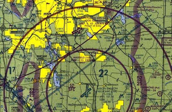 We had been listening to CAK approach for about 5-10 minutes prior to our initial radio contact, and there wasn't much happening. So we waited until we were about 20nm out before contacting CAK approach. I must admit that I was a little sheepish as I intoned "Canton-Akron Approach, Cessna November-7-1-0-6-Golf" a couple of times with no acknowledgment from the controller. There had popped up a bunch of arrivals, some that were visual and some that were ILS, and he just didn't have time to talk to me. Finally after about 4-5 tries to communicate, the last of which was a little on the forceful side (from Walt), we received a frequency code and admission to Class C airspace. There was a decent amount of traffic out and about (saw the Goodyear Blimp at about 3000ft), but we were cleared to land from about 5 miles out.
 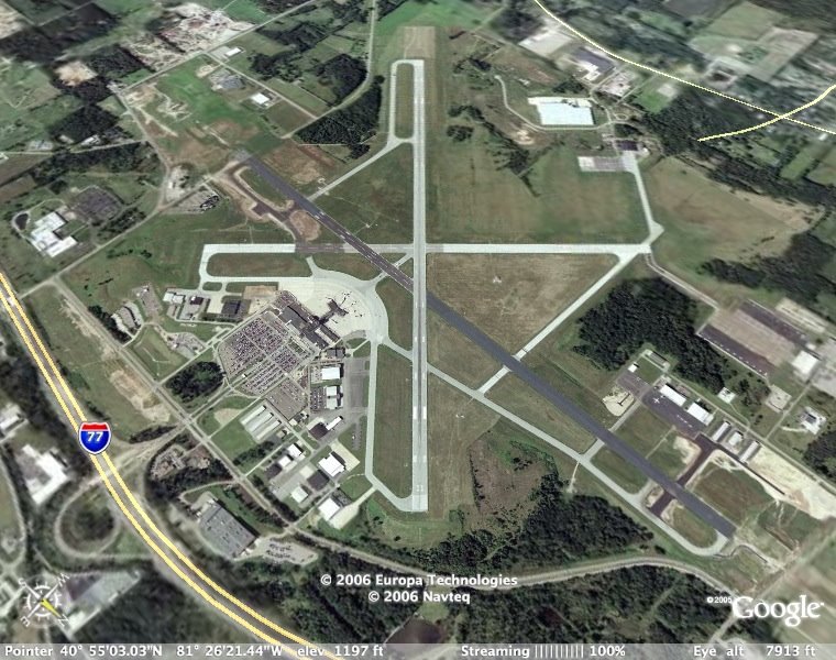 Because of our western heading, I entered the pattern on the base leg, and practically had a straight-in approach from about 3 miles out. It's a nice, long, wide runway, but I managed to land nicely, and not flare 10 feet above the pavement as I had in Mansfield. We requested a full-stop landing, so I turned on the first taxiway and held short as a AirTran 717 landed on Runway 19 right in front of me!
  There were a couple of Canadair RJ's and even a 747-200 parked on the ramp. It was pretty exciting for me! I felt like I was a big shot, landing at an airport with the big boys (even though my C172 would've been blown over by all of them). I saw in my mind's eye, a little kid looking out the window of the airliner as it rolled to a stop saying "Look, mommy! Look at that little plane with the propeller!". Yeah, time to head for home:). I taxied back to Runway 23, and took off for home. We crusied at 2500ft, and Walt pointed out just about every Amish restaurant between Canton and Coshocton on the way back. About 35 miles from I40, we again spotted the smokestacks of Conesville, and knew that we were headed in the right direction.
Landing in Coshocton, we picked up 20.6gal of fuel, which wasn't too bad for 2.3hrs of flight time. About 9gal per hour - I will put that into the memory banks and remember that fuel burn rate. Walt signed me off for unlimited cross-country to a few local airports, so I can go out on a nice day and actually land at a different airport! I'll be praticing some navigation and will put together an out-and-back cross-country, but that's for another day. Today, I got my cross-country endorsement! Woo-hoo!
posted by Delta Whiskey @ 10:28 PM
![]()

0 Comments:
Post a Comment
<< Home