
Last week, I went to an industry tradeshow in New Orleans, and part of the hard work was flying down in the DA40 (the stresses of the job, let me tell you). Monday morning, we had a really beautiful trip ahead of us. A front had just gone through, and it was clear skies and unlimited ceilings all the way from Ohio to Louisiana. Here's a picture of N470DS, sitting on the ramp, waiting to stretch its wings. I was supposed to meet Dad at the airport at 7AM to leave, and I was about 5 minutes late. I sat around for a while, and no Dad. So, I gave him a call, and he was running a little behind schedule. Dad had been in a hurry to leave, because he wanted to make it down to New Orleans in enough time to play 18 holes before nightfall. However, we'd have to book it to make it down. Monday morning was quite cold - 10°F! I was glad that I had warm gloves as I pulled the aircraft out of the hangar. After Dad showed up, we loaded the plane, pulled the nose plugs, and headed south. The air was really cold, as you can see from the photo I took of the Muskingum River valley over Coshocton. The AEP Conesville Powerplant was churning out the water vapor, giving a really unique misty look to the valley from the air.
 Looking south down the Muskingum River towards the AEP Conesville Powerplant
However cold the air was at the surface, it began warming up very quickly as we gained altitude. While the air at the surface was about -12°C (10°F), about 4500ft up, we had gained temperature to about 3°C (39°F). It started to get so warm that we had to turn the cabin heater down!
.JPG) A very frozen and four-wheelered Dillion Reservoir, north of Zanesville, OH
A very frozen and four-wheelered Dillion Reservoir, north of Zanesville, OHThe separation of the colder moist air layer close to the ground and the warmer air layer above it, really gave a very dramatic inversion layer. Here's a couple of photographs of the airlayers. Please forgive the dirt on the lens - the camera needs a dusting.
 Plumes from two powerplants on the Muskingum River, south of Zanesville, OH
 Looking east up the Ohio River Valley, just over Portsmouth, OH
 The very chilly town of Portsmouth, OH - sunlight on frosted hills in the morning - Beautiful!
The further south we went, over Kentucky, the air continued to warm up and some familiar landmarks came into view. Here's a series of photos of the
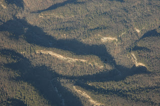
Red River Gorge and
Cave Run Lake area in East-Central Kentucky - I've spent a lot of time in that area, but I think that this is one area more beautiful from the ground than the air. Correction - everything's more beautiful from the air....maybe just a little more recognizable:).
 Over Cave Run Lake, Kentucky at about 8500ft MSL
 A typical sandstone bluff in the Red River Gorge - I think that I've camped on this bluff, but it's hard to tell from the air
Well, I tried to find
Natural Bridge, Kentucky, but it's fairly hard to see from the air. You see that thin strip of sandstone in the center of the picture below? That's it. You really have to know where to look - it's not an overpowering natural wonder from the sky:). From the ground, however, it's a sight to behold.
 Natural Bridge, Kentucky from 7500ft MSL
After wasting a little time circling over Daniel Boone National forest in Kentucky, we turned south and kept flying. Our route down was very similar to the route that I took when I flew to Bay Minette, AL along the gulf coast. That was the
last flight of N7016G, but this time I was flying in the DA40, with a G1000 and longer legs. Since we had more fuel on board, we bypassed Rockwood, TN for Fort Payne, AL, just south of Chattanooga. We determined that
Isbell Field (4A9) was just about the half-way point between Coshocton and New Orleans at 395NM enroute. The turn was very quick, the service was friendly, and the locals were talking about someone driving through their chicken barns. It's hilarious how you can walk into any small airport and it's like you've found the same set of old codgers, sitting around talking about the weather.
 Looking south over the Appalachians, towards Knoxville, TN and the Smoky Mountains from 8500ft MSL
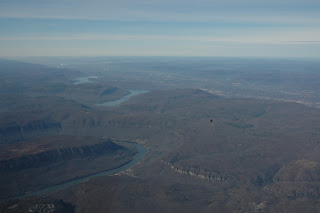 The winding Chattanooga River, cutting through the plateau right outside Chattanooga, TN. Beautiful!
 Here's a nice little house with a Million-dollar view of the river valley!
 A quick turn and refuel at Valley Aviation in Fort Payne, IN
After refueling, we headed south to Birmingham, AL, then south-west over Mississippi towards New Orleans. We called Birmingham approach and stayed away from the traffic, and about 40 miles south, we got handed off to...nothing. Apparently, there's no low-level ARTCC in this part of the country. After flying over endless swamps, hills, rivers, and few towns any bigger than Warsaw, OH, I can see why. Central Mississippi is almost a desert...with trees and the occasional river. One thing that has become abundantly clear to me during my air travels is that there is no shortage of open spaces and land in this country. While large metropolitain areas become more and more crowded, there is more than enough elbow room for billions of people in this vast land.
 A river barge, loaded with grain, slowly chugging its way south through Mississippi
 Central Mississippi
It's always dramatic as you approach the ocean. You see the coastline appear, first as a false horizon about 80-100miles out, then it becomes more and more apparent that you're looking at the coast, not the horizon. I knew from the maps that
Lake Pontchartrain is huge, but you can't really get a good sense of how huge, until you see it from the air.
 Looking south at the Gulf Coast near New Orleans and Biloxi, MS
  The truly vast, truly shallow Lake Pontchartrain
 North Coast of Lake Pontchartrain
 Houses ready for the flooding along the north shore of Lake Pontchartrain
As we were over the middle of Lake Pontchartrain, Dad suddenly realized that we were missing LIFE JACKETS! Don't tell the plane that we're over water, I told him, and it'll never know. Besides, how else would you want to approach Lakefront airport? Over the flooded, bombed-out houses? Yeah, give me some dirty salt water anytime. We descended into Lakefront Airport, with a nice little 8KT cross-wind, landed, rolled out and parked the plane. It had been 745NM from Coshocton, and took about 6.4hrs on the Hobbs meter. Not too shabby for a day of flying! Now, next on the agenda was golf!
 AHH!!! Water, Water, everywhere on the MFD!!!!
 Lakefront Airport (KNEW) from about 8 miles out over Lake Pontchartrain
 Short Final for 18R at Lakefront Airport (KNEW)
 I recently watched this first-rate documentary about the war in Iraq, and the subsequent occupation. Since this war has been going on for almost five years, you forget about the reports of chaos and rioting that were happening in 2003. It's an honest look at the failures of the Bush administration in planning for an extended occupation. Contrast that with the intense planning that happened almost two years in advance for the occupation of Germany following WWII, and you can begin to see how this whole conflict has been mismanaged by a bunch of NeoCon hacks. Again, thanks to the freedom of the internet, you can watch it here.


.JPG)


